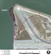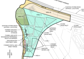
It was the 1950s, before the environmental movement of the 1970s and the laws that followed in its wake. Hauling waste materials out to the western shoreline of Alameda Point to be burned and bulldozed into the Bay was not considered irresponsible. The “Burn Area,” as it is called, lies next to the shore near the entrance to the Oakland Estuary.

By 2009, the Navy was ready with a plan to finally remove several acres of contaminated Burn Area soil and haul it away. In 2010, testing by the cleanup contractor preparing to do the work, however, revealed additional burn residue that extends over a longer area and under the shoreline slope. The new information triggered a complete re-evaluation of the plan.
Excavation and removal at the greater depth and under the shore would drive the cost up from the original $5 million to $40 million. Fortunately for the Navy, a new and lower cost option became available just as the Navy and regulatory agencies were gathering more soil and groundwater data and discussing options.
In 2011, the US Army Corps of Engineers approved a shoreline steel containment system called an “open cell vertical confined disposal facility.” Primarily used for harbor and waterway reinforcement and as a containment area for dredge sediment, the system is also suitable for permanently isolating and containing the toxic burn material along several hundred feet of Bay shoreline. This option will cost $13 million.

The Navy calls the open cell system a “waste isolation bulkhead.” It consists of a wall of interlocked steel plates embedded in the earth along the shoreline. Perpendicular steel walls extend toward the shoreline to form cells, or compartments, and provide anchorage. The absence of welding to hold the system together allows it to flex without failing and eliminates the problem of welds corroding.
Tests around the Burn Area were conducted in 2010, 2011, and 2012 to determine if any of the chemicals in the burn residue were entering San Francisco Bay. None were found to be entering the Bay. Nevertheless, the Burn Area’s proximity to the Bay requires that it either be removed or permanently isolated.
The Burn Area is located on the 37-acre Site 1 cleanup area. The site includes about a half dozen unlined underground pits that were used for waste disposal and are now partially covered by runway pavement.

Cleanup of a solvent plume on Site 1 that posed a potential threat to the Bay took place last year. Previous cleanup on the site included removal of debris and soil contaminated by radium-226 used in painting luminescent aircraft dials.
When the Navy is finished with the Burn Area bulkhead barrier, the Burn Area will again be tested for radiological contamination. All 37 acres of Site 1 will then be covered by at least two feet of clean soil and seeded with native grasses.
Site 1 will be available for passive recreational use as part of the proposed 147-acre regional park along the northern shoreline. Site 1 will be part of the final conveyance of land to the city slated for 2019. The VA’s property is adjacent and to the south and east.
The Navy’s project manager along with the cleanup contractor for Site 1 will be present at a special public meeting to answer questions and take comments on the new proposed plan for the Burn Area. The meeting is on April 9 at the Alameda Main Library, 1550 Oak Street, from 6:30 pm to 8:00 pm.
Originally published in the Alameda Sun.
Further Reading on the Navy’s Burn Area Study
The Navy’s recently-completed soil and groundwater study for the Burn Area is called a Focused Feasibility Study (FFS) and is located on the state Envirostor website.
The FFS is very large and is divided into parts. Recommended parts to look at first:
Part 1, Part 3 (cool maps), Part 4 (mostly raw data, but has trench photos), and Part 8 (descriptive letters from PND Engineers that own the patent on the open cell system, and all the comments by the regulatory agencies and the responses to comments.) Part 5 has a lot of technical data and description of the groundwater model in relation to the Bay.
Reference material on the open cell barrier proposed for the Burn Area:
US Army Corps of Engineers 2011 report on the use of the Open Cell Sheet Pile Containment System for contaminated dredge material.
Overview of the Open Cell Confinement Disposal Facility system by PND Engineers.
2012 report to the Alaska Legislature on the Open Cell system.
Image highlights from the Focused Feasibility Study for the Site 1 Burn Area
Click on images to enlarge.


